
http://icons.wxug.com/data/images/blogs/atl_ir4_sat_tropicalindex_anim

http://icons.wxug.com/data/images/blogs/carib_ir4_sat_tropicalindex_anim

http://icons.wxug.com/data/images/blogs/pr_ir4_sat_tropicalindex_anim

http://www.nhc.noaa.gov/

http://www.jpl.nasa.gov/images/earth/africa/africa-20060726-browse.jpg


http://www.wunderground.com/hurricane/

http://tropic.ssec.wisc.edu/real-time/salmain.php?&prod=splitE&time=

http://forecast.uoa.gr/LINKS/DUST/dust.php?field=dconc&lan=en

http://www.myfoxhurricane.com/custom/models/gfs.html
http://www.myfoxhurricane.com/custom/models/wrf.html
Tormentas Eléctricas
http://www.blitzortung.org/Webpages/index.php?lang=es&page_0=36
Seguimiento Incendios Forestales NASA
https://earthdata.nasa.gov/labs/worldview/
Satélite RD
http://wunderground.com/data/images/g2_ir.jpg
http://maps.wunderground.com/data/640x480/2xg2_ir_anim.gif
http://images.ibsys.com/sh/images/weather/auto/ir_g2_640x480.jpg
Satélite CARIBE
http://wunderground.com/data/images/g3_ir.jpg
http://maps.wunderground.com/data/640x480/2xg3_ir_anim.gif
http://www.weather.com/maps/geography/oceans/caribbeansatellite_large_animated.html
http://images.ibsys.com/sh/images/weather/auto/ir_g3_640x480.jpg
Satélite ATLÁNTICO
http://maps.wunderground.com//data/640x480/2xat_ir.gif
http://maps.wunderground.com//data/640x480/2xat_ir_anim.gif
http://images.ibsys.com/sh/images/weather/auto/ir_at_640x480.jpg
Convertidor Distancia
http://es.metric-conversions.org/longitud/millas-a-kilometros.htm
Convertidor Longitud-Latitud a kilómetros y millas
http://www.tutiempo.net/p/distancias/calcular_distancias.html
Convertidor Temperaturas
http://es.metric-conversions.org/temperatura/celsios-a-fahrenheit.htm
Tropical Tidbid
http://www.tropicaltidbits.com/analysis/models/gfs/2016101306/gfs_mslp_pcpn_watl_1.png
http://www.tropicaltidbits.com/analysis/models/?model=gfs®ion=watl&pkg=mslp_pcpn_frzn&runtime=2016101306&fh=6
Wunderground Tropical
http://wunderground.com/hurricane
Análisis de superficie: CARIBE, ATLÁNTICO Y GOLFO DE MÉXICO
http://www.nhc.noaa.gov/tafb/ATSA_12Z.gif
http://www.ssd.noaa.gov/goes/east/tatl/avn-l.jpg
http://www.ssd.noaa.gov/goes/east/watl/avn-l.jpg
http://www.ssd.noaa.gov/goes/east/catl/avn-l.jpg
http://www.ssd.noaa.gov/goes/east/carb/avn-l.jpg
http://www.ssd.noaa.gov/goes/east/gmex/avn-l.jpg
http://www.ssd.noaa.gov/goes/east/nwatl/avn-l.jpg
Modelo Computarizado A
http://www.wpc.ncep.noaa.gov/mike/gfs/crb_p24i_gfs00f024.gif
http://www.wpc.ncep.noaa.gov/mike/gfs/crb_p24i_gfs00f048.gif
http://www.wpc.ncep.noaa.gov/mike/gfs/crb_p24i_gfs00f072.gif
http://www.wpc.ncep.noaa.gov/mike/gfs/crb_p24i_gfs00f096.gif
http://www.wpc.ncep.noaa.gov/mike/gfs/crb_p24i_gfs00f120.gif
http://www.wpc.ncep.noaa.gov/mike/gfs/crb_p24i_gfs00f144.gif
Modelo Computarizado B
http://mag.ncep.noaa.gov/data/gfs/00/gfs_wnatl_024_precip_ptot_l.gif
http://mag.ncep.noaa.gov/data/gfs/00/gfs_wnatl_036_precip_ptot_l.gif
http://mag.ncep.noaa.gov/data/gfs/00/gfs_wnatl_048_precip_ptot_l.gif
http://mag.ncep.noaa.gov/data/gfs/00/gfs_wnatl_060_precip_ptot_l.gif
http://mag.ncep.noaa.gov/data/gfs/00/gfs_wnatl_072_precip_ptot_l.gif
http://mag.ncep.noaa.gov/data/gfs/00/gfs_wnatl_084_precip_ptot_l.gif
http://mag.ncep.noaa.gov/data/gfs/00/gfs_wnatl_096_precip_ptot_l.gif
http://mag.ncep.noaa.gov/data/gfs/00/gfs_wnatl_108_precip_ptot_l.gif
http://mag.ncep.noaa.gov/data/gfs/00/gfs_wnatl_120_precip_ptot_l.gif
http://mag.ncep.noaa.gov/data/gfs/00/gfs_wnatl_132_precip_ptot_l.gif
http://mag.ncep.noaa.gov/data/gfs/00/gfs_wnatl_144_precip_ptot_l.gif
http://mag.ncep.noaa.gov/data/gfs/00/gfs_wnatl_156_precip_ptot_l.gif
Modelo Computarizado C
http://mag.ncep.noaa.gov/data/gfs/00/gfs_atlantic_012_10m_wnd_precip.gif
http://mag.ncep.noaa.gov/data/gfs/00/gfs_atlantic_024_10m_wnd_precip.gif
http://mag.ncep.noaa.gov/data/gfs/00/gfs_atlantic_036_10m_wnd_precip.gif
http://mag.ncep.noaa.gov/data/gfs/00/gfs_atlantic_048_10m_wnd_precip.gif
http://mag.ncep.noaa.gov/data/gfs/00/gfs_atlantic_060_10m_wnd_precip.gif
http://mag.ncep.noaa.gov/data/gfs/00/gfs_atlantic_072_10m_wnd_precip.gif
http://mag.ncep.noaa.gov/data/gfs/00/gfs_atlantic_084_10m_wnd_precip.gif
http://mag.ncep.noaa.gov/data/gfs/00/gfs_atlantic_096_10m_wnd_precip.gif
http://mag.ncep.noaa.gov/data/gfs/00/gfs_atlantic_108_10m_wnd_precip.gif
http://mag.ncep.noaa.gov/data/gfs/00/gfs_atlantic_120_10m_wnd_precip.gif
http://mag.ncep.noaa.gov/data/gfs/00/gfs_atlantic_132_10m_wnd_precip.gif
http://mag.ncep.noaa.gov/data/gfs/00/gfs_atlantic_144_10m_wnd_precip.gif
http://mag.ncep.noaa.gov/data/gfs/00/gfs_atlantic_156_10m_wnd_precip.gif
http://mag.ncep.noaa.gov/data/gfs/00/gfs_atlantic_168_10m_wnd_precip.gif
http://mag.ncep.noaa.gov/data/gfs/00/gfs_atlantic_180_10m_wnd_precip.gif
http://mag.ncep.noaa.gov/data/gfs/00/gfs_atlantic_192_10m_wnd_precip.gif
http://mag.ncep.noaa.gov/data/gfs/00/gfs_atlantic_204_10m_wnd_precip.gif
http://mag.ncep.noaa.gov/data/gfs/00/gfs_atlantic_216_10m_wnd_precip.gif
http://mag.ncep.noaa.gov/data/gfs/00/gfs_atlantic_228_10m_wnd_precip.gif
http://mag.ncep.noaa.gov/data/gfs/00/gfs_atlantic_240_10m_wnd_precip.gif
http://mag.ncep.noaa.gov/data/gfs/00/gfs_atlantic_252_10m_wnd_precip.gif
http://mag.ncep.noaa.gov/data/gfs/00/gfs_atlantic_264_10m_wnd_precip.gif
http://mag.ncep.noaa.gov/data/gfs/00/gfs_atlantic_276_10m_wnd_precip.gif
http://mag.ncep.noaa.gov/data/gfs/00/gfs_atlantic_288_10m_wnd_precip.gif
http://mag.ncep.noaa.gov/data/gfs/00/gfs_atlantic_300_10m_wnd_precip.gif
http://mag.ncep.noaa.gov/data/gfs/00/gfs_atlantic_312_10m_wnd_precip.gif
http://mag.ncep.noaa.gov/data/gfs/00/gfs_atlantic_324_10m_wnd_precip.gif
http://mag.ncep.noaa.gov/data/gfs/00/gfs_atlantic_336_10m_wnd_precip.gif
http://mag.ncep.noaa.gov/data/gfs/00/gfs_atlantic_348_10m_wnd_precip.gif
http://mag.ncep.noaa.gov/data/gfs/00/gfs_atlantic_360_10m_wnd_precip.gif
http://mag.ncep.noaa.gov/data/gfs/00/gfs_atlantic_372_10m_wnd_precip.gif
http://mag.ncep.noaa.gov/data/gfs/00/gfs_atlantic_384_10m_wnd_precip.gif
Modelo Computarizado D
http://www.rap.ucar.edu/weather/progs/prog12hr.gif
http://www.rap.ucar.edu/weather/progs/prog24hr.gif
http://www.rap.ucar.edu/weather/progs/prog36hr.gif
http://www.rap.ucar.edu/weather/progs/prog48hr.gif
Modelo Computarizado E
http://mag.ncep.noaa.gov/model-guidance-model-parameter.php?group=Model%20Guidance&model=gfs&area=wnatl&cycle=20150514%2012%20UTC¶m=precip_p60&fourpan=no&imageSize=M&ps=area
Páginas Clima NASA
http://goes.gsfc.nasa.gov/goescolor/goeseast/hurricane2/color_med/latest.jpg
http://goes.gsfc.nasa.gov/goescolor/goeswest/pacific2/color_med/latest.jpg
http://earthobservatory.nasa.gov/
Pronóstico marino 1
http://www.nhc.noaa.gov/tafb_latest/atl24_latestBW.gif
http://www.nhc.noaa.gov/tafb_latest/atl48_latestBW.gif
http://www.nhc.noaa.gov/tafb_latest/atl72_latestBW.gif
http://www.nhc.noaa.gov/tafb_latest/WATL_latest.gif
http://icons.wxug.com/data/images/blogs/carib_ir4_sat_tropicalindex_anim
http://icons.wxug.com/data/images/blogs/pr_ir4_sat_tropicalindex_anim
http://www.nhc.noaa.gov/
http://www.jpl.nasa.gov/images/earth/africa/africa-20060726-browse.jpg
http://www.wunderground.com/hurricane/
http://tropic.ssec.wisc.edu/real-time/salmain.php?&prod=splitE&time=
http://forecast.uoa.gr/LINKS/DUST/dust.php?field=dconc&lan=en
http://www.myfoxhurricane.com/custom/models/gfs.html
http://www.myfoxhurricane.com/custom/models/wrf.html
Tormentas Eléctricas
http://www.blitzortung.org/Webpages/index.php?lang=es&page_0=36
Seguimiento Incendios Forestales NASA
https://earthdata.nasa.gov/labs/worldview/
Satélite RD
http://wunderground.com/data/images/g2_ir.jpg
http://maps.wunderground.com/data/640x480/2xg2_ir_anim.gif
http://images.ibsys.com/sh/images/weather/auto/ir_g2_640x480.jpg
Satélite CARIBE
http://wunderground.com/data/images/g3_ir.jpg
http://maps.wunderground.com/data/640x480/2xg3_ir_anim.gif
http://www.weather.com/maps/geography/oceans/caribbeansatellite_large_animated.html
http://images.ibsys.com/sh/images/weather/auto/ir_g3_640x480.jpg
Satélite ATLÁNTICO
http://maps.wunderground.com//data/640x480/2xat_ir.gif
http://maps.wunderground.com//data/640x480/2xat_ir_anim.gif
http://images.ibsys.com/sh/images/weather/auto/ir_at_640x480.jpg
Convertidor Distancia
http://es.metric-conversions.org/longitud/millas-a-kilometros.htm
Convertidor Longitud-Latitud a kilómetros y millas
http://www.tutiempo.net/p/distancias/calcular_distancias.html
Convertidor Temperaturas
http://es.metric-conversions.org/temperatura/celsios-a-fahrenheit.htm
Tropical Tidbid
http://www.tropicaltidbits.com/analysis/models/gfs/2016101306/gfs_mslp_pcpn_watl_1.png
http://www.tropicaltidbits.com/analysis/models/?model=gfs®ion=watl&pkg=mslp_pcpn_frzn&runtime=2016101306&fh=6
Wunderground Tropical
http://wunderground.com/hurricane
Análisis de superficie: CARIBE, ATLÁNTICO Y GOLFO DE MÉXICO
http://www.nhc.noaa.gov/tafb/ATSA_12Z.gif
http://www.ssd.noaa.gov/goes/east/tatl/avn-l.jpg
http://www.ssd.noaa.gov/goes/east/watl/avn-l.jpg
http://www.ssd.noaa.gov/goes/east/catl/avn-l.jpg
http://www.ssd.noaa.gov/goes/east/carb/avn-l.jpg
http://www.ssd.noaa.gov/goes/east/gmex/avn-l.jpg
http://www.ssd.noaa.gov/goes/east/nwatl/avn-l.jpg
Modelo Computarizado A
http://www.wpc.ncep.noaa.gov/mike/gfs/crb_p24i_gfs00f024.gif
http://www.wpc.ncep.noaa.gov/mike/gfs/crb_p24i_gfs00f048.gif
http://www.wpc.ncep.noaa.gov/mike/gfs/crb_p24i_gfs00f072.gif
http://www.wpc.ncep.noaa.gov/mike/gfs/crb_p24i_gfs00f096.gif
http://www.wpc.ncep.noaa.gov/mike/gfs/crb_p24i_gfs00f120.gif
http://www.wpc.ncep.noaa.gov/mike/gfs/crb_p24i_gfs00f144.gif
Modelo Computarizado B
http://mag.ncep.noaa.gov/data/gfs/00/gfs_wnatl_024_precip_ptot_l.gif
http://mag.ncep.noaa.gov/data/gfs/00/gfs_wnatl_036_precip_ptot_l.gif
http://mag.ncep.noaa.gov/data/gfs/00/gfs_wnatl_048_precip_ptot_l.gif
http://mag.ncep.noaa.gov/data/gfs/00/gfs_wnatl_060_precip_ptot_l.gif
http://mag.ncep.noaa.gov/data/gfs/00/gfs_wnatl_072_precip_ptot_l.gif
http://mag.ncep.noaa.gov/data/gfs/00/gfs_wnatl_084_precip_ptot_l.gif
http://mag.ncep.noaa.gov/data/gfs/00/gfs_wnatl_096_precip_ptot_l.gif
http://mag.ncep.noaa.gov/data/gfs/00/gfs_wnatl_108_precip_ptot_l.gif
http://mag.ncep.noaa.gov/data/gfs/00/gfs_wnatl_120_precip_ptot_l.gif
http://mag.ncep.noaa.gov/data/gfs/00/gfs_wnatl_132_precip_ptot_l.gif
http://mag.ncep.noaa.gov/data/gfs/00/gfs_wnatl_144_precip_ptot_l.gif
http://mag.ncep.noaa.gov/data/gfs/00/gfs_wnatl_156_precip_ptot_l.gif
Modelo Computarizado C
http://mag.ncep.noaa.gov/data/gfs/00/gfs_atlantic_012_10m_wnd_precip.gif
http://mag.ncep.noaa.gov/data/gfs/00/gfs_atlantic_024_10m_wnd_precip.gif
http://mag.ncep.noaa.gov/data/gfs/00/gfs_atlantic_036_10m_wnd_precip.gif
http://mag.ncep.noaa.gov/data/gfs/00/gfs_atlantic_048_10m_wnd_precip.gif
http://mag.ncep.noaa.gov/data/gfs/00/gfs_atlantic_060_10m_wnd_precip.gif
http://mag.ncep.noaa.gov/data/gfs/00/gfs_atlantic_072_10m_wnd_precip.gif
http://mag.ncep.noaa.gov/data/gfs/00/gfs_atlantic_084_10m_wnd_precip.gif
http://mag.ncep.noaa.gov/data/gfs/00/gfs_atlantic_096_10m_wnd_precip.gif
http://mag.ncep.noaa.gov/data/gfs/00/gfs_atlantic_108_10m_wnd_precip.gif
http://mag.ncep.noaa.gov/data/gfs/00/gfs_atlantic_120_10m_wnd_precip.gif
http://mag.ncep.noaa.gov/data/gfs/00/gfs_atlantic_132_10m_wnd_precip.gif
http://mag.ncep.noaa.gov/data/gfs/00/gfs_atlantic_144_10m_wnd_precip.gif
http://mag.ncep.noaa.gov/data/gfs/00/gfs_atlantic_156_10m_wnd_precip.gif
http://mag.ncep.noaa.gov/data/gfs/00/gfs_atlantic_168_10m_wnd_precip.gif
http://mag.ncep.noaa.gov/data/gfs/00/gfs_atlantic_180_10m_wnd_precip.gif
http://mag.ncep.noaa.gov/data/gfs/00/gfs_atlantic_192_10m_wnd_precip.gif
http://mag.ncep.noaa.gov/data/gfs/00/gfs_atlantic_204_10m_wnd_precip.gif
http://mag.ncep.noaa.gov/data/gfs/00/gfs_atlantic_216_10m_wnd_precip.gif
http://mag.ncep.noaa.gov/data/gfs/00/gfs_atlantic_228_10m_wnd_precip.gif
http://mag.ncep.noaa.gov/data/gfs/00/gfs_atlantic_240_10m_wnd_precip.gif
http://mag.ncep.noaa.gov/data/gfs/00/gfs_atlantic_252_10m_wnd_precip.gif
http://mag.ncep.noaa.gov/data/gfs/00/gfs_atlantic_264_10m_wnd_precip.gif
http://mag.ncep.noaa.gov/data/gfs/00/gfs_atlantic_276_10m_wnd_precip.gif
http://mag.ncep.noaa.gov/data/gfs/00/gfs_atlantic_288_10m_wnd_precip.gif
http://mag.ncep.noaa.gov/data/gfs/00/gfs_atlantic_300_10m_wnd_precip.gif
http://mag.ncep.noaa.gov/data/gfs/00/gfs_atlantic_312_10m_wnd_precip.gif
http://mag.ncep.noaa.gov/data/gfs/00/gfs_atlantic_324_10m_wnd_precip.gif
http://mag.ncep.noaa.gov/data/gfs/00/gfs_atlantic_336_10m_wnd_precip.gif
http://mag.ncep.noaa.gov/data/gfs/00/gfs_atlantic_348_10m_wnd_precip.gif
http://mag.ncep.noaa.gov/data/gfs/00/gfs_atlantic_360_10m_wnd_precip.gif
http://mag.ncep.noaa.gov/data/gfs/00/gfs_atlantic_372_10m_wnd_precip.gif
http://mag.ncep.noaa.gov/data/gfs/00/gfs_atlantic_384_10m_wnd_precip.gif
Modelo Computarizado D
http://www.rap.ucar.edu/weather/progs/prog12hr.gif
http://www.rap.ucar.edu/weather/progs/prog24hr.gif
http://www.rap.ucar.edu/weather/progs/prog36hr.gif
http://www.rap.ucar.edu/weather/progs/prog48hr.gif
Modelo Computarizado E
http://mag.ncep.noaa.gov/model-guidance-model-parameter.php?group=Model%20Guidance&model=gfs&area=wnatl&cycle=20150514%2012%20UTC¶m=precip_p60&fourpan=no&imageSize=M&ps=area
Páginas Clima NASA
http://goes.gsfc.nasa.gov/goescolor/goeseast/hurricane2/color_med/latest.jpg
http://goes.gsfc.nasa.gov/goescolor/goeswest/pacific2/color_med/latest.jpg
http://earthobservatory.nasa.gov/
Pronóstico marino 1
http://www.nhc.noaa.gov/tafb_latest/atl24_latestBW.gif
http://www.nhc.noaa.gov/tafb_latest/atl48_latestBW.gif
http://www.nhc.noaa.gov/tafb_latest/atl72_latestBW.gif
http://www.nhc.noaa.gov/tafb_latest/WATL_latest.gif
http://www.opc.ncep.noaa.gov/UA/Atl_Tropics.gif
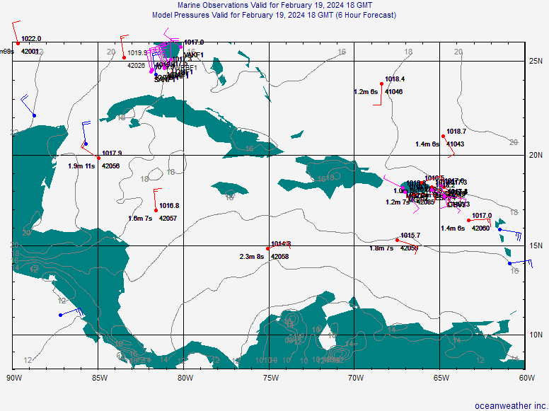
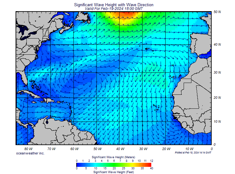
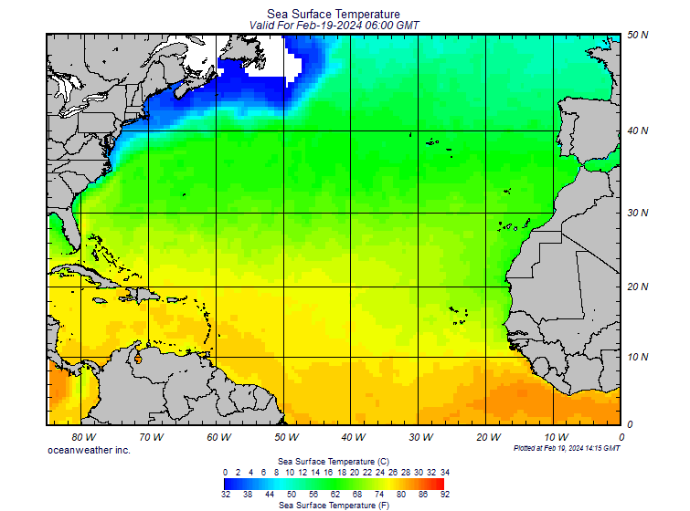
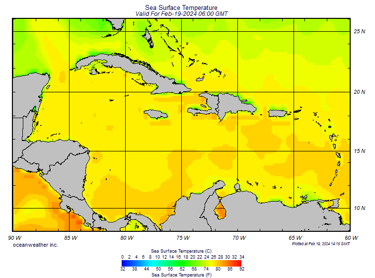
Pronóstico marino 2
http://oceanweather.com/data/Caribbean-Sea/WAVE000.GIF
http://oceanweather.com/data/Caribbean-Sea/marineM00.gif
http://oceanweather.com/data/Caribbean-Sea/SST.GIF
Pronóstico marino 3
https://oceanography.navy.mil/legacy/web/cgi-bin/graphic.pl/metoc/368/21/0-0-1/0
Pronóstico marino 4
http://oceanweather.com/data/NATL-Southern/WAVE000.GIF
http://oceanweather.com/data/NATL-Southern/marineM00.gif
http://oceanweather.com/data/NATL-Southern/SST.GIF
Pronóstico marino 5
http://polar.ncep.noaa.gov/waves/viewer.shtml?-multi_1-latest-hs-atlantic-
http://polar.ncep.noaa.gov/waves/viewer.shtml?-multi_1-US_puertorico
http://dadecosurf.com/nww3_height
http://dadecosurf.com/images/nec_000.gif
http://dadecosurf.com/images/nec_006.gif
http://dadecosurf.com/images/nec_012.gif
http://dadecosurf.com/images/nec_024.gif
http://dadecosurf.com/images/nec_036.gif
http://dadecosurf.com/images/nec_048.gif
http://dadecosurf.com/images/nec_060.gif
http://dadecosurf.com/images/nec_072.gif
http://dadecosurf.com/images/nec_084.gif
http://dadecosurf.com/images/nec_096.gif
http://dadecosurf.com/images/nec_108.gif
http://dadecosurf.com/images/nec_120.gif
http://dadecosurf.com/images/nec_132.gif
http://dadecosurf.com/images/nec_144.gif
http://dadecosurf.com/images/nec_156.gif
http://dadecosurf.com/images/nec_168.gif
http://dadecosurf.com/images/nec_180.gif
http://dadecosurf.com/nww3_period
http://dadecosurf.com/images/nec_000.2.gif
http://dadecosurf.com/images/nec_006.2.gif
http://dadecosurf.com/images/nec_012.2.gif
http://dadecosurf.com/images/nec_024.2.gif
http://dadecosurf.com/images/nec_036.2.gif
http://dadecosurf.com/images/nec_048.2.gif
http://dadecosurf.com/images/nec_060.2.gif
http://dadecosurf.com/images/nec_072.2.gif
http://dadecosurf.com/images/nec_084.2.gif
http://dadecosurf.com/images/nec_096.2.gif
http://dadecosurf.com/images/nec_108.2.gif
http://dadecosurf.com/images/nec_120.2.gif
http://dadecosurf.com/images/nec_132.2.gif
http://dadecosurf.com/images/nec_144.2.gif
http://dadecosurf.com/images/nec_156.2.gif
http://dadecosurf.com/images/nec_168.2.gif
http://dadecosurf.com/images/nec_180.2.gif
Pronóstico marino 6
http://www.wavewatch.com/Surf-Forecast-Region.php?RegionID=54
http://www.weather.com/outlook/recreation/boatandbeach/surf/region?oceanid=natl®id=pur
(Atlántico)
http://www.wavewatch.com/Surf-Forecast-North-Atlantic.php
http://www.wavewatch.com/maps/pur_wind_006.jpg
http://www.wavewatch.com/maps/pur_wind_012.jpg
http://www.wavewatch.com/maps/pur_wind_018.jpg
http://www.wavewatch.com/maps/pur_wind_024.jpg
http://www.wavewatch.com/maps/pur_wind_030.jpg
http://www.wavewatch.com/maps/pur_wind_036.jpg
http://www.wavewatch.com/maps/pur_wind_042.jpg
http://www.wavewatch.com/maps/pur_wind_048.jpg
http://www.wavewatch.com/maps/pur_wind_054.jpg
http://www.wavewatch.com/maps/pur_wind_060.jpg
http://www.wavewatch.com/maps/pur_wind_066.jpg
http://www.wavewatch.com/maps/pur_wind_072.jpg
http://www.wavewatch.com/maps/pur_wind_078.jpg
http://www.wavewatch.com/maps/pur_wind_084.jpg
http://www.wavewatch.com/maps/pur_wind_090.jpg
http://www.wavewatch.com/maps/pur_wind_096.jpg
http://www.wavewatch.com/maps/pur_wind_102.jpg
http://www.wavewatch.com/maps/pur_wind_108.jpg
http://www.wavewatch.com/maps/pur_wind_114.jpg
http://www.wavewatch.com/maps/pur_wind_102.jpg
http://www.wavewatch.com/maps/pur_wind_126.jpg
http://www.wavewatch.com/maps/pur_wind_132.jpg
http://www.wavewatch.com/maps/pur_wind_138.jpg
http://www.wavewatch.com/maps/pur_wind_144.jpg
http://www.wavewatch.com/maps/pur_wind_150.jpg
http://www.wavewatch.com/maps/pur_wind_156.jpg
http://www.wavewatch.com/maps/pur_wind_162.jpg
http://www.wavewatch.com/maps/pur_wind_168.jpg
http://www.wavewatch.com/maps/pur_surf_006.jpg
http://www.wavewatch.com/maps/pur_surf_012.jpg
http://www.wavewatch.com/maps/pur_surf_018.jpg
http://www.wavewatch.com/maps/pur_surf_024.jpg
http://www.wavewatch.com/maps/pur_surf_030.jpg
http://www.wavewatch.com/maps/pur_surf_036.jpg
http://www.wavewatch.com/maps/pur_surf_042.jpg
http://www.wavewatch.com/maps/pur_surf_048.jpg
http://www.wavewatch.com/maps/pur_surf_054.jpg
http://www.wavewatch.com/maps/pur_surf_060.jpg
http://www.wavewatch.com/maps/pur_surf_066.jpg
http://www.wavewatch.com/maps/pur_surf_072.jpg
http://www.wavewatch.com/maps/pur_surf_078.jpg
http://www.wavewatch.com/maps/pur_surf_084.jpg
http://www.wavewatch.com/maps/pur_surf_090.jpg
http://www.wavewatch.com/maps/pur_surf_096.jpg
http://www.wavewatch.com/maps/pur_surf_102.jpg
http://www.wavewatch.com/maps/pur_surf_108.jpg
http://www.wavewatch.com/maps/pur_surf_114.jpg
http://www.wavewatch.com/maps/pur_surf_120.jpg
http://www.wavewatch.com/maps/pur_surf_126.jpg
http://www.wavewatch.com/maps/pur_surf_132.jpg
http://www.wavewatch.com/maps/pur_surf_138.jpg
http://www.wavewatch.com/maps/pur_surf_144.jpg
http://www.wavewatch.com/maps/pur_surf_150.jpg
http://www.wavewatch.com/maps/pur_surf_156.jpg
http://www.wavewatch.com/maps/pur_surf_162.jpg
http://www.wavewatch.com/maps/pur_surf_168.jpg
Pronóstico marino 7
http://www.windfinder.com/forecasts/wind_caribbean_animation.htm
http://www.windfinder.com/forecasts/wind_cent_am_animation.htm
http://www.windfinder.com/grafiken/forecasts/wind_caribbean12.png
http://www.windfinder.com/grafiken/forecasts/wind_caribbean24.png
http://www.windfinder.com/grafiken/forecasts/wind_caribbean36.png
http://www.windfinder.com/grafiken/forecasts/wind_caribbean48.png
http://www.windfinder.com/grafiken/forecasts/wind_caribbean60.png
http://www.windfinder.com/grafiken/forecasts/wind_caribbean72.png
http://www.windfinder.com/grafiken/forecasts/wind_caribbean84.png
http://www.windfinder.com/grafiken/forecasts/wind_caribbean96.png
http://www.windfinder.com/grafiken/forecasts/wind_caribbean108.png
http://www.windfinder.com/grafiken/forecasts/wind_caribbean120.png
http://www.windfinder.com/grafiken/forecasts/wind_caribbean132.png
http://www.windfinder.com/grafiken/forecasts/wind_caribbean144.png
http://www.windfinder.com/grafiken/forecasts/wind_caribbean156.png
http://www.windfinder.com/grafiken/forecasts/wind_caribbean168.png
Temperaturas
http://www.rap.ucar.edu/weather/model/displayMod.php?var=gfs_sfc_temp&loop=1
http://www.rap.ucar.edu/weather/model/gfs000hr_sfc_temp.gif
http://www.rap.ucar.edu/weather/model/gfs006hr_sfc_temp.gif
http://www.rap.ucar.edu/weather/model/gfs012hr_sfc_temp.gif
http://www.rap.ucar.edu/weather/model/gfs018hr_sfc_temp.gif
http://www.rap.ucar.edu/weather/model/gfs024hr_sfc_temp.gif
http://www.rap.ucar.edu/weather/model/gfs030hr_sfc_temp.gif
http://www.rap.ucar.edu/weather/model/gfs036hr_sfc_temp.gif
http://www.rap.ucar.edu/weather/model/gfs042hr_sfc_temp.gif
http://www.rap.ucar.edu/weather/model/gfs048hr_sfc_temp.gif
http://www.rap.ucar.edu/weather/model/gfs054hr_sfc_temp.gif
http://www.rap.ucar.edu/weather/model/gfs060hr_sfc_temp.gif
http://www.rap.ucar.edu/weather/model/gfs066hr_sfc_temp.gif
http://www.rap.ucar.edu/weather/model/gfs072hr_sfc_temp.gif
http://www.rap.ucar.edu/weather/model/gfs078hr_sfc_temp.gif
http://www.rap.ucar.edu/weather/model/gfs084hr_sfc_temp.gif
http://www.rap.ucar.edu/weather/model/gfs090hr_sfc_temp.gif
http://www.rap.ucar.edu/weather/model/gfs096hr_sfc_temp.gif
http://www.rap.ucar.edu/weather/model/gfs102hr_sfc_temp.gif
http://www.rap.ucar.edu/weather/model/gfs108hr_sfc_temp.gif
http://www.rap.ucar.edu/weather/model/gfs114hr_sfc_temp.gif
http://www.rap.ucar.edu/weather/model/gfs120hr_sfc_temp.gif
http://www.rap.ucar.edu/weather/model/gfs126hr_sfc_temp.gif
http://www.rap.ucar.edu/weather/model/gfs132hr_sfc_temp.gif
http://www.rap.ucar.edu/weather/model/gfs138hr_sfc_temp.gif
http://www.rap.ucar.edu/weather/model/gfs144hr_sfc_temp.gif
http://www.rap.ucar.edu/weather/model/gfs150hr_sfc_temp.gif
http://www.rap.ucar.edu/weather/model/gfs156hr_sfc_temp.gif
http://www.rap.ucar.edu/weather/model/gfs162hr_sfc_temp.gif
http://www.rap.ucar.edu/weather/model/gfs168hr_sfc_temp.gif
http://www.rap.ucar.edu/weather/model/gfs174hr_sfc_temp.gif
http://www.rap.ucar.edu/weather/model/gfs180hr_sfc_temp.gif
Modelos: GFS y SERVIR
http://www.rap.ucar.edu/weather/model/index.php?model=gfs
http://www.servir.net/index.php?option=com_content&task=view&id=91&Itemid=85
RD
http://www.servir.net/index.php?option=com_content&task=view&id=99&Itemid=85
Punto de rocío
http://www.rap.ucar.edu/weather/model/gfs000hr_sfc_dewp.gif
http://www.rap.ucar.edu/weather/model/gfs006hr_sfc_dewp.gif
http://www.rap.ucar.edu/weather/model/gfs012hr_sfc_dewp.gif
http://www.rap.ucar.edu/weather/model/gfs018hr_sfc_dewp.gif
http://www.rap.ucar.edu/weather/model/gfs024hr_sfc_dewp.gif
http://www.rap.ucar.edu/weather/model/gfs030hr_sfc_dewp.gif
http://www.rap.ucar.edu/weather/model/gfs036hr_sfc_dewp.gif
http://www.rap.ucar.edu/weather/model/gfs042hr_sfc_dewp.gif
http://www.rap.ucar.edu/weather/model/gfs048hr_sfc_dewp.gif
http://www.rap.ucar.edu/weather/model/gfs054hr_sfc_dewp.gif
http://www.rap.ucar.edu/weather/model/gfs060hr_sfc_dewp.gif
http://www.rap.ucar.edu/weather/model/gfs066hr_sfc_dewp.gif
http://www.rap.ucar.edu/weather/model/gfs072hr_sfc_dewp.gif
http://www.rap.ucar.edu/weather/model/gfs078hr_sfc_dewp.gif
http://www.rap.ucar.edu/weather/model/gfs084hr_sfc_dewp.gif
http://www.rap.ucar.edu/weather/model/gfs090hr_sfc_dewp.gif
http://www.rap.ucar.edu/weather/model/gfs096hr_sfc_dewp.gif
http://www.rap.ucar.edu/weather/model/gfs102hr_sfc_dewp.gif
http://www.rap.ucar.edu/weather/model/gfs108hr_sfc_dewp.gif
http://www.rap.ucar.edu/weather/model/gfs114hr_sfc_dewp.gif
http://www.rap.ucar.edu/weather/model/gfs120hr_sfc_dewp.gif
http://www.rap.ucar.edu/weather/model/gfs126hr_sfc_dewp.gif
http://www.rap.ucar.edu/weather/model/gfs132hr_sfc_dewp.gif
http://www.rap.ucar.edu/weather/model/gfs138hr_sfc_dewp.gif
http://www.rap.ucar.edu/weather/model/gfs144hr_sfc_dewp.gif
http://www.rap.ucar.edu/weather/model/gfs150hr_sfc_dewp.gif
http://www.rap.ucar.edu/weather/model/gfs156hr_sfc_dewp.gif
http://www.rap.ucar.edu/weather/model/gfs162hr_sfc_dewp.gif
http://www.rap.ucar.edu/weather/model/gfs168hr_sfc_dewp.gif
http://www.rap.ucar.edu/weather/model/gfs174hr_sfc_dewp.gif
http://www.rap.ucar.edu/weather/model/gfs180hr_sfc_dewp.gif
Agua precipitable
http://www.rap.ucar.edu/weather/model/displayMod.php?var=gfs_sfc_prcp&loop=1
http://www.rap.ucar.edu/weather/model/gfs000hr_sfc_pwat.gif
http://www.rap.ucar.edu/weather/model/gfs006hr_sfc_pwat.gif
http://www.rap.ucar.edu/weather/model/gfs012hr_sfc_pwat.gif
http://www.rap.ucar.edu/weather/model/gfs018hr_sfc_pwat.gif
http://www.rap.ucar.edu/weather/model/gfs024hr_sfc_pwat.gif
http://www.rap.ucar.edu/weather/model/gfs030hr_sfc_pwat.gif
http://www.rap.ucar.edu/weather/model/gfs036hr_sfc_pwat.gif
http://www.rap.ucar.edu/weather/model/gfs042hr_sfc_pwat.gif
http://www.rap.ucar.edu/weather/model/gfs048hr_sfc_pwat.gif
http://www.rap.ucar.edu/weather/model/gfs054hr_sfc_pwat.gif
http://www.rap.ucar.edu/weather/model/gfs060hr_sfc_pwat.gif
http://www.rap.ucar.edu/weather/model/gfs066hr_sfc_pwat.gif
http://www.rap.ucar.edu/weather/model/gfs072hr_sfc_pwat.gif
http://www.rap.ucar.edu/weather/model/gfs078hr_sfc_pwat.gif
http://www.rap.ucar.edu/weather/model/gfs084hr_sfc_pwat.gif
http://www.rap.ucar.edu/weather/model/gfs090hr_sfc_pwat.gif
http://www.rap.ucar.edu/weather/model/gfs096hr_sfc_pwat.gif
http://www.rap.ucar.edu/weather/model/gfs102hr_sfc_pwat.gif
http://www.rap.ucar.edu/weather/model/gfs108hr_sfc_pwat.gif
http://www.rap.ucar.edu/weather/model/gfs114hr_sfc_pwat.gif
http://www.rap.ucar.edu/weather/model/gfs120hr_sfc_pwat.gif
http://www.rap.ucar.edu/weather/model/gfs126hr_sfc_pwat.gif
http://www.rap.ucar.edu/weather/model/gfs132hr_sfc_pwat.gif
http://www.rap.ucar.edu/weather/model/gfs138hr_sfc_pwat.gif
http://www.rap.ucar.edu/weather/model/gfs144hr_sfc_pwat.gif
http://www.rap.ucar.edu/weather/model/gfs150hr_sfc_pwat.gif
http://www.rap.ucar.edu/weather/model/gfs156hr_sfc_pwat.gif
http://www.rap.ucar.edu/weather/model/gfs162hr_sfc_pwat.gif
http://www.rap.ucar.edu/weather/model/gfs168hr_sfc_pwat.gif
http://www.rap.ucar.edu/weather/model/gfs174hr_sfc_pwat.gif
http://www.rap.ucar.edu/weather/model/gfs180hr_sfc_pwat.gif
Temperatura del Mar Caribe
https://oceanography.navy.mil/legacy/web/products/K10/caribbeank10.gif
http://image.espanol.weather.com/web/maps/marine/web_intl_caribbean_centralamerica_sst_720x486.jpg
http://www.oceanweather.com/data/Caribbean-Sea/SST.GIF
http://www.oceanweather.com/data/NATL-Southern/SST.GIF
http://isotherm.rsmas.miami.edu/heat/data/tsst_latest.gif
Otros
http://www.wunderground.com/data/640x480/huratl_slp.gif
http://assets.panda.org/img/original/monthly_temperatures_caribbean.gif